For some of us, mountains are the best places for a vacation, but for others is a way of living.
I’m talking about climbers that take their chances to make it “on top of the world”, conquering some of the highest mountains out there.
But some are not only after heights, they’re after the most dangerous mountains.
They need adrenaline, even if they have to pay with their lives and that’s why we decided to make up a list with the deadliest mountains in the world.
Here’s our list of World’s Most Dangerous Mountains:
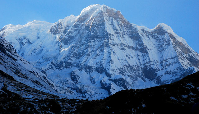
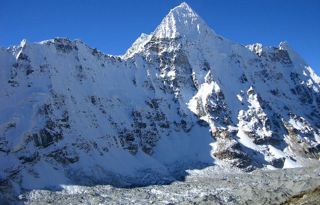
ANNAPURNA (26,545 ft.)
(Central Nepal)
| Highest point | |
|---|---|
| Elevation | 8,091 m (26,545 ft) |
| Ranked 10th | |
| Prominence | 2,984 m (9,790 ft) |
| Ranked 100th | |
| Parent peak | Cho Oyu |
| Listing | Eight-thousander |
| Ultra | |
| Coordinates | 28°35′46″N 83°49′13″E 28°35′46″N 83°49′13″E |
| Geography | |
| Location | Gandaki Zone , Nepal |
| Parent range | Himalayas |
| Climbing | |
| First ascent | 3 June 1950 |
| Maurice Herzog and Louis Lachenal | |
| (First winter ascent 3 February 1987 Jerzy Kukuczka and Artur Hajzer ) | |
| Easiest route | northwest face |
On this mountain, the 10th highest in the world, about 130 climbers have summited the avalanche-prone peak, but 53 have died trying — making Annapurna’s fatality rate of 41% the highest in the world.
NANGA PARBAT (26,657 ft.)
(Kashmir)
| Highest point | |
|---|---|
| Elevation | 8,126 m (26,660 ft) |
| Ranked 9th | |
| Prominence | 4,608 m (15,118 ft) |
| Ranked 14th | |
| Listing | Eight-thousander |
| Ultra | |
| Coordinates | 35°14′15″N 74°35′21″E 35°14′15″N 74°35′21″E |
| Location | Gilgit–Baltistan , Pakistan Nanga Parbat lies approx 27km west-southwest of Astore district , in the Gilgit–Baltistan region of Pakistan |
| Parent range | Himalayas |
| Climbing | |
| First ascent | July 3, 1953 by Hermann Buhl |
| Easiest route | Diamir district (West Face) |
Known affectionately as the Man Eater, this craggy monster in Kashmir is an enormous ridge of rock and ice.
The peak is the ninth highest in the world and its southern side features the tallest mountain face on the planet.
Nanga Parbat claimed 31 lives before it was conquered by Austrian Herman Buhl in 1953.
SIULA GRANDE (20,814 ft.)
(Peruvian Andes)
| Highest point | |
|---|---|
| Elevation | 6,344 m (20,814 ft) |
| Coordinates | 10°17′S 76°53′W 10°17′S 76°53′W |
| Geography | Peru |
| Parent range | Andes , Waywash |
| Climbing | |
| First ascent | July 28, 1936 |
| Easiest route | glacier/snow/ice climb |
In 1985, the duo of Joe Simpson and Simon Yates, whose journey was chronicled in the book and film Touching the Void, attempted the western face of Siula Grande: a sheer, vertical ascent that had never been completed.
They made it to the summit but Simpson fell during the descent, breaking his leg.
Then Yates, lowering the injured Simpson down by rope, lost sight of him over a cliff.
After an hour passed, with his position slipping away, and Simpson unable to secure himself, Yates cut the rope.
Incredibly, Simpson survived the 100 ft. fall into a crevasse.
Over the next three days he subsisted on melted snow and hopped the five miles back to camp, arriving shortly before Yates, assuming Simpson had perished, was due to depart for home.
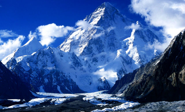
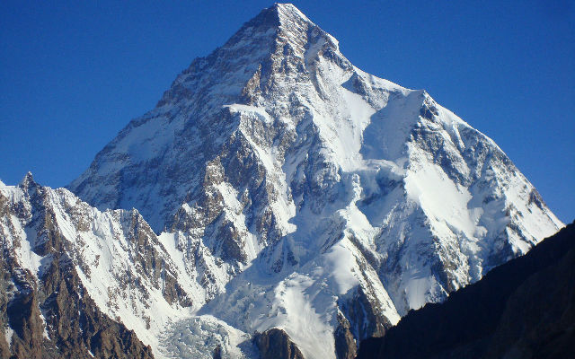
K2 (28,251 ft.)
(Border of Pakistan & China)
| Highest point | |
|---|---|
| Elevation | 8,611 m (28,251 ft) |
| Ranked 2nd | |
| Prominence | 4,017 m (13,179 ft) |
| Ranked 22nd | |
| Coordinates | 35°52′57″N 76°30′48″E 35°52′57″N 76°30′48″E |
| Geography | Baltistan , Gilgit–Baltistan , Pakistan |
| Tashkurgan , Xinjiang , China | |
| Parent range | Karakoram |
| Climbing | |
| First ascent | 31 July 1954 |
| Achille Compagnoni | |
| Lino Lacedelli | |
| Easiest route | Abruzzi Spur |
The second highest mountain in the world, this peak has a nasty reputation, especially when it comes to female climbers.
The first woman to reach the summit was the legendary Polish climber Wanda Rutkiewicz, who got to the top in June 1986. Over the next 18 years all five female climbers who summited this peak were killed.
Three died during the descent down K2, two others on nearby mountains. Rutkiewicz also perished close by, on Kangchenjunga in 1992.
The curse was finally broken in 2004 by Edurne Pasaban, a 31-year-old Spanish mountaineer, who remains alive to this day.
KANGCHENJUNGA (28,169 ft.)
(Border between India & Nepal)
| Highest point | |
|---|---|
| Elevation | 8,586 m (28,169 ft) |
| Ranked 3rd | |
| Prominence | 3,922 m (12,867 ft) |
| Ranked 29th | |
| Coordinates | 27°42′09″N 88°08′48″E 27°42′09″N 88°08′48″E |
| Geography | |
| Location | Nepal–India border |
| Parent range | Himalayas |
| Climbing | |
| First ascent | 25 May 1955 |
| Joe Brown & George Band | |
| (First winter ascent 11 January 1986 Jerzy Kukuczka and Krzysztof Wielicki ) | |
| Easiest route | glacier/snow/ice climb |
In 1999, a new James Bond novel found the uber-agent trekking up its dramatic ridges.
James may have stopped to admire the gorgeous view, but, as our hero knows well, looks can be deceiving.
Avalanches and bitter colds have made this one of the deadliest mountains in the world.
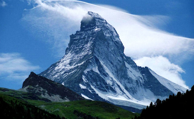
THE MATTERHORN (14,691 ft.)
(Border between Switzerland & Italy)
| Highest point | |
|---|---|
| Elevation | 4,478 m (14,692 ft) |
| Prominence | 1,042 m (3,419 ft) |
| Isolation | 13.8 km (8.6 mi) |
| Parent peak | Weisshorn |
| Coordinates | 45°58′35″N 7°39′30″E 45°58′35″N 7°39′30″E |
| Naming | Translation: Peak of the Meadows |
| Geography | |
| Location | Aosta Valley , Italy |
| Valais , Switzerland | |
| Parent range | Pennine Alps |
| Topo map | Swisstopo 1347 Matterhorn |
| Climbing | |
| First ascent | July 14, 1865 by |
| Edward Whymper | |
| Charles Hudson | |
| Francis Douglas | |
| Douglas Robert Hadow | |
| Michel Croz | |
| Peter Taugwalder (father) | |
| Peter Taugwalder (son) | |
| Easiest route | Hörnli ridge (AD, rock/mixed climb) |
These days the principle danger on the Matterhorn is its popularity, with overeager tourists sending loose rocks onto the heads of fellow climbers below.
EVEREST (29,029 ft.)
(Border between Nepal & China)
| Highest point | |
|---|---|
| Elevation | 8,848 m (29,029 ft) |
| Ranked 1st | |
| Prominence | 8,848 m (29,029 ft) |
| Ranked 1st | |
| (Notice special definition for Everest) | |
| Coordinates | 27°59′17″N 86°55′31″E 27°59′17″N 86°55′31″E |
| Geography | |
| Location | Solukhumbu District , Sagarmatha Zone , Nepal ; |
| Tingri County , Xigazê , Tibet Autonomous Region , China | |
| Parent range | Mahalangur Himal , Himalayas |
| Climbing | |
| First ascent | 29 May 1953 |
| Edmund Hillary & Tenzing Norgay | |
| (First winter ascent 1980 Leszek Cichy and Krzysztof Wielicki) | |
| Normal route | southeast ridge (Nepal) |
With its marquee status, it would be easy to assume that this is the deadliest mountain of them all. But pound for pound, Everest claims a fairly small percentage of climbers (9%), considering the number that attempt it every year.
MT. WASHINGTON (6,288 ft)
(New Hampshire)
| Highest point | |
|---|---|
| Elevation | 6,288 ft (1,917 m) NAVD 88 |
| Prominence | 6,148 ft (1,874 m) |
| Coordinates | 44°16′14″N 71°18′12″W 44°16′14″N 71°18′12″W |
| Geography | |
| Location | Sargent's Purchase , Coös County , New Hampshire , U.S. |
| Parent range | Presidential Range |
| Topo map | USGS Mount Washington |
| Climbing | |
| First ascent | 1642 (first recorded) |
| Easiest route | Hike , ride cog railway , or drive via Mount Washington Auto Road . |
To experience a killer mountain a little closer to home, look no further than this New Hampshire peak.
The rapidly shifting weather, hurricane force winds, and summer ice pellets scouring this slope have claimed more than 100 lives.
Temperatures at the peak can descend to -50 degrees Farenheit.
In fact, the strongest wind gust ever measured on Earth was recorded on this peak, a gale of 231 mph.
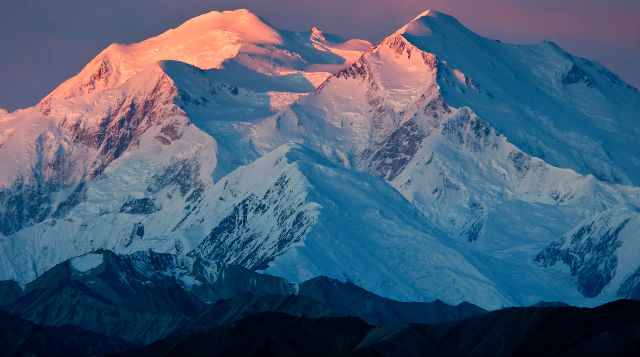
DENALI (20,320 ft.)
(Alaska)
| Highest point | |
|---|---|
| Elevation | 20,310 ft (6190 m) top of snow NAVD88 |
| Prominence | 20,146 ft (6140 m) |
| Isolation | 4629 mi (7450 km) |
| Coordinates | 63°04′10″N 151°00′27″W 63°04′10″N 151°00′27″W |
| Geography | |
| Location | Denali National Park and Preserve , Alaska , U.S. |
| Parent range | Alaska Range |
| Topo map | USGS Mt. McKinley A-3 |
| Climbing | |
| First ascent | June 7, 1913 by |
| Hudson Stuck | |
| Harry Karstens | |
| Walter Harper | |
| Robert Tatum | |
| Easiest route | West Buttress Route (glacier/snow climb) |
The mountain is prone to earthquakes.
And the combination of high altitude and extreme latitude also means altitude sickness kicks in much faster.
(At the equator, a peak this size would have about half as much oxygen at the summit than at sea level; because of the latitude, the percentage on Denali is far lower.)
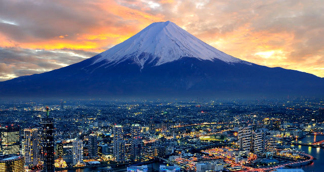
Mt. Fuji (12,388 ft.)
(Japan)
| Highest point | |
|---|---|
| Prominence | 3,776 m (12,388 ft) |
| Ranked 35th | |
| Coordinates | 35°21′29″N 138°43′52″E 35°21′29″N 138°43′52″E |
| Geography | |
| Topo map | Geospatial Information Authority 25000:1 富士山 |
| 50000:1 富士山 | |
| Geology | |
| Mountain type | Stratovolcano |
| Last eruption | 1707 to 1708 |
| Climbing | |
| First ascent | 663 by an anonymous monk |
| Easiest route | Hiking |
| UNESCO World Heritage Site | |
| Official name | Fujisan, sacred place and source of artistic inspiration |
| Type | Cultural |
| Criteria | iii, vi |
| Designated | 2013 (37th session) |
| State Party | Japan |
| Region | Asia |
Sometimes you don’t have to be a tall mountain to be a lethal one.
Take Mt. Fuji, for example. At its base sits the Sea of Trees, a large expanse of cedar, pine, and boxwood trees that was the only area not overrun by lava and ash during a massive eruption in 1707.
This forest, know as Aokigahara, has attained cult status among Japanese as the perfect place to die.
Rumors about the woods abound: locals speak of magnetic fields that disorient search and rescue operations; the forest’s population is said to consist of snakes, wild dogs, and the occasional demon.
Beautiful entry, as a tour guide I love read something about landscapes like that, keep it up, thumbed up and shared a link on my wall, your friend, Carlos from Brazil owner of English tips
Just by reading the entries, it gives me shivers…. I’m having a slight fear of height especially if I don’t have something to lean/hold on to… Anyway, all are great landscapes!